I am aware that participating in Skiing, snowboarding, telemarking, ski touring, split boarding, snow shoeing, hiking, mountain biking and other forms of winter / summer travel (hereinafter collectively referred to as “wilderness activities“) inside, or beyond the ski/bike area boundary involves many inherent risks, dangers and hazards including, but not limited to: boarding, riding and disembarking ski lifts; changing weather conditions; exposed rock, earth, ice, or other natural objects; trees, tree wells, tree stumps and forest dead fall; the condition of mountain bike trails including changes in dirt consistency; the condition of snow or ice on or beneath the snow surface; changes or variation in the terrain used for skiing, snowboarding, telemarking, touring and mountain biking which may create blind spots or areas of reduced visibility; changes or variations in the snow surface or subsurface, including changes due to man-made or artificial snow; variable and difficult snow conditions; streams, creeks and exposed holes in the snow pack above streams or creeks; cliffs; crevasses; impact or collision with lift structures, fences, summer construction vehicles, snow making equipment, snow grooming equipment, snowcats, snowmobiles and other vehicles, equipment, structures, or objects or equipment used in connection with skiing, snowboarding, mountain biking and Special Events; snowcat roads, road-banks or cut-banks; impact or collision with other skiers, snowboarders, telemarkers, ski tourers and mountain bikers; avalanches; the failure to ride, ski or snowboard safely or within one’s own ability or within designated areas; ; negligence of other skiers, snowboarders, telemarkers, ski tourers and bikers, ; and NEGLIGENCE ON THE PART OF THE RELEASEES.
NEGLIGENCE includes failure on the part of the releasees to take reasonable steps to safeguard or protect me from the risks, dangers and hazards associated with wilderness activities; and failure of the releasees to accurately map, mark and make visible bike trails and ski runs and their locations, ski area boundaries, specialized area boundaries (including, but not limited to: Training and Recreational areas), cliff/avalanche hazards, water reservoirs, creek hazards, ski hikes and traverses, closure sign lines, permanently closed areas, trails, roads and provincial park areas; and failure to produce an accurate mapping product, including but not limited to: Contour elevation markers, contour line placement, geographical coordinates, datums, projections, magnetic declination and scale.
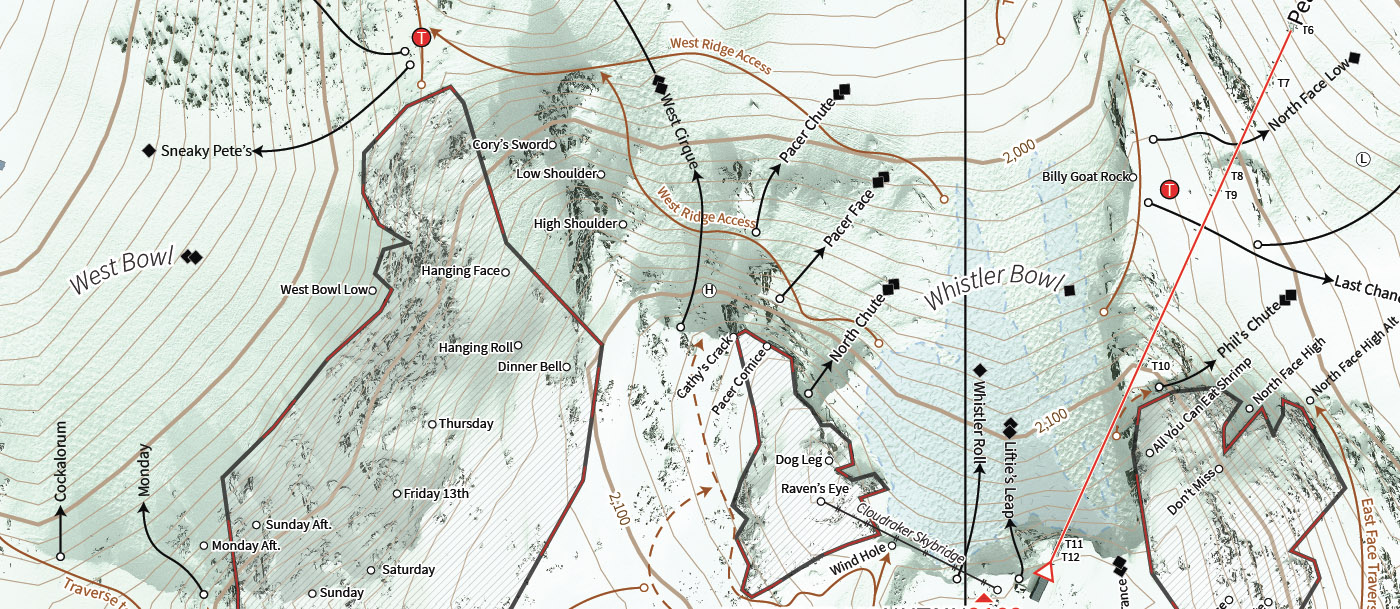
I am also aware that the risks, dangers and hazards referred to above exist throughout the area used for skiing, snowboarding, telemarking, ski touring and mountain biking and that MANY ARE NOT MARKED ON ULLR MAPS. I understand and accept that ULLR MAPS ARE TO BE USED FOR GENERAL REFERENCE PURPOSES ONLY AND IN NO WAY IS THEIR ACCURACY GUARANTEED and I am solely responsible for decisions made while skiing, snowboarding, telemarking, ski touring and mountain biking. Furthermore, I understand and acknowledge that GPS features (including the ability to pinpoint one’s location) embedded in ULLR maps are approximations only. I understand that factors including satellite line of site, tree cover, terrain variations, proximity to man-made structures and interference from electronic devices can interfere with GPS signal reception and accuracy. I accept and acknowledge that the releasees cannot guarantee cell phone reception or GPS accuracy and that both are dependent on satellite and cellular networks and their respective signal strength. I AM AWARE OF THE RISKS, DANGERS AND HAZARDS ASSOCIATED WITH WILDERNESS ACTIVITIES AND I FREELY ACCEPT AND FULLY ASSUME ALL SUCH RISKS, DANGERS AND HAZARDS AND THE POSSIBILITY OF PERSONAL INJURY, DEATH, PROPERTY DAMAGE OR LOSS RESULTING THEREFROM.